
Technology
Six technologies behind one living twin
Detecting a pothole in an image is the easy part. Making that detection accurate enough, located precisely enough and verifiable enough to justify public spending is the hard part, and that is the work these six technologies do.
5 steps · Capture → Detect → Locate → Rank → Act
One drive-by, five steps, a works programme
Nothing about the survey is exotic. A normal vehicle drives the network once, and what comes back is a ranked list your technical office can act on.
- 01 · Capture
Any vehicle
Three cameras, an inertial unit and a GNSS receiver. No lane closure, no dedicated fleet, no disruption to traffic.
up to 130 km/h - 02 · Detect
AI on board
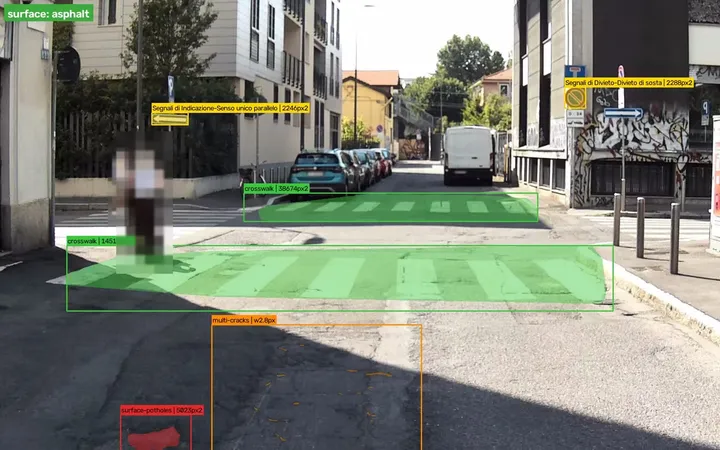
Distress, crossings and signage classified and graded as you drive. Faces and plates are blurred before anything is stored.
on device - 03 · Locate
Authenticated position
Every finding carries coordinates and a timestamp whose authenticity can be demonstrated, not just asserted.
20 cm - 04 · Rank
Severity and exposure
In the cloud, severity, traffic exposure and deterioration trend combine into a single order of work.
cloud - 05 · Act
A repair list
A map and a prioritised works programme, exportable to your asset management system or straight into a budget request.
same day
One capture feeds every module. There is no second survey to pay for.
-
01
Computer vision and deep learning
Models trained on real European road surfaces, not on synthetic data.
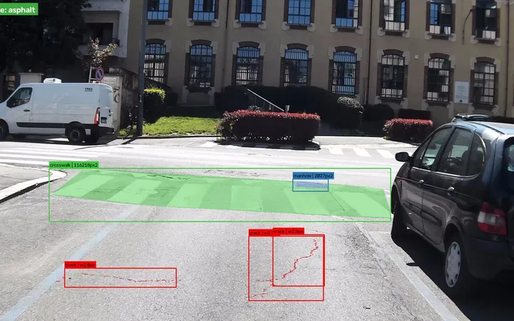
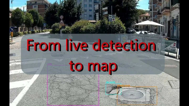
Our detection models identify and classify road distress, crossing condition and signage in real time, at survey speed. Each detection carries a confidence score and a severity grade rather than a simple yes or no.
The models improve with every campaign. New road types, new lighting conditions and new failure modes feed back into training, so accuracy in your specific network rises the longer we work on it.

-
02
Authenticated satellite positioning
Every observation stamped in time and position, with proof the coordinates are genuine.
Galileo OSNMA authenticates the navigation signal, so spoofing and tampering are detectable and the position and timestamp on each record can be trusted in a technical review, a liability dispute or an insurance claim. For an insurer or a concessionaire, that difference is the whole point.
Accuracy follows the job: about 20 cm with the Galileo High Accuracy Service, 3 cm with RTK. A crew arrives and finds the defect without searching, and the same asset surveyed twice lands in the same place on the map.
-
03
Earth observation and InSAR
Copernicus data reveals the ground movement that causes the defect.
Street-level capture tells you the surface is cracking. Satellite interferometry tells you the ground underneath is subsiding — which is why it keeps cracking after every repair.
Combining the two gives a dual-layer view: centimetre detail where the vehicle drove, and millimetre-per-year ground motion across the whole territory. The InSAR layer was developed during our incubation at ESA BIC Turin; rainfall, heat islands, wildfire risk and soil type will feed the predictive model too.

-
04
Cloud processing and dashboard
From raw capture to an actionable map, without a GIS specialist.
Captures are processed in the cloud and published to an interactive dashboard. Filter by defect type or severity, inspect the source image, export to your asset management system or generate the report your council meeting needs.
Maintenance scheduling is built in: prioritise, assign, close out and keep the audit trail of what was repaired and when.

-
05
Inertial measurement
The sensor that feels what the camera cannot see.
An IMU records the vehicle’s response to the road surface along all axes. Roughness, subtle deformation and early-stage rutting show up in the motion signal well before they are visually obvious.
Fusing IMU with vision catches defects at the stage where a low-cost repair still works, instead of at the stage where resurfacing is the only option.

-
06
On-device anonymisation
Faces and plates never leave the vehicle.
Anonymisation runs on the edge device at capture time. Faces and number plates are blurred irreversibly before anything is stored or transmitted, so no identifiable image ever reaches our infrastructure.
This is a design decision, not a policy promise: the pipeline is built so that GDPR compliance is structural. We capture road condition — nothing else.
Watch the 2-minute demo
Living baseline
A plug-and-play device with three industrial cameras captures everything visible from the road at driving speed: defects, signage, drains, poles, vegetation. Calibrated cameras measure sizes and distances, and every observation is stamped in time and position by Galileo OSNMA.
Let’s keep your infrastructure alive
Send us a street, a district, a box of paper plans or an entire network. We will build the first layer of your twin, and you decide whether the numbers are worth a conversation.